
Why Cape Town is so hot this week: recent temperatures, today's forecast, and what comes next
SA Weather Reports analysis - 10 November 2026
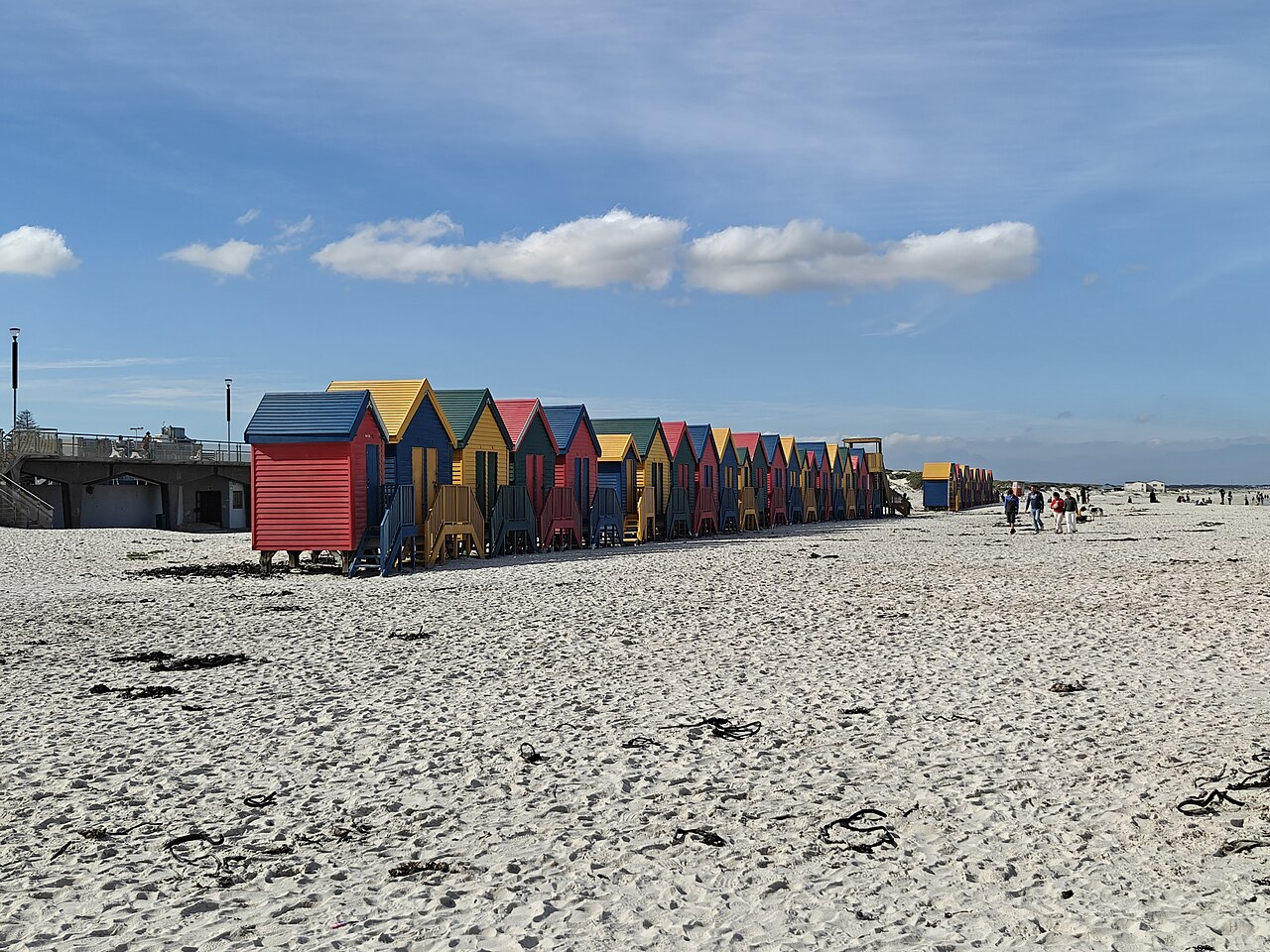
Muizenberg Beach, Cape Town. Photo: Husskeyy, CC BY-SA 4.0, via Wikimedia Commons.
If the last couple of days in Cape Town have felt unusually hot to you, you are not imagining it - and today is forecast to keep it going. We went through what the South African Weather Service (SAWS) and other meteorologists are saying, the measured numbers behind the heat so far, and what is driving it. Here is the picture.
How hot has it been, really?
Sunday was already well above normal: the weather station at Cape Town International Airport measured a maximum of 28.3°C, against a typical November high of about 22°C. On Monday 9 November the same station measured 33.1°C. Inland it was hotter still: Upington measured 38.4°C (its forecast had been 37°C), Kimberley 33.1°C and George 30.0°C (measured maxima from the official station reports, published via Ogimet; Stellenbosch and Paarl, which SAWS forecast at 34°C and 37°C, were not in the measured feed we checked).
Today the extreme heat is expected to sit inland. SAWS's forecast for Tuesday has Cape Town at 28°C, Paarl at 34°C, Kimberley at 37°C and Upington at 39°C, with very hot to extremely hot and uncomfortable conditions - maximums of 36 to 40°C - expected over the Namakwa district of the Northern Cape and the interior of the Western Cape. At Cape Town International the station reported 17.1°C at 08:00, so the city's peak for today is still ahead.
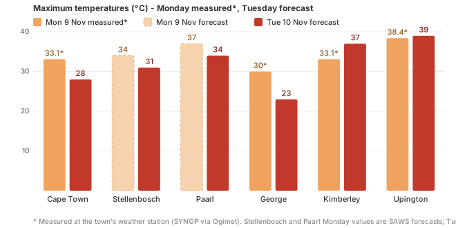
Monday 9 November as measured at the towns' official weather stations (solid bars, via Ogimet SYNOP reports - Stellenbosch and Paarl Monday values are SAWS forecasts, dashed), and SAWS's forecasts for Tuesday 10 November (as published by The South African). The worst of the heat is inland; George on the coast stays mildest.
For Cape Town city itself, today's forecast depends on who you ask. SAWS's morning forecast put the city at about 28°C. MET Norway - the provider behind the town forecasts on this website - forecast about 33°C at midday in its 07:20 SAST model run, and Open-Meteo, a second independent provider, forecast 31°C. That spread is normal: the city bowl, the Atlantic seaboard and the northern suburbs often differ by several degrees on a hot day, and each model handles the sea breeze differently. What every provider agrees on is a forecast above the typical November high for today.
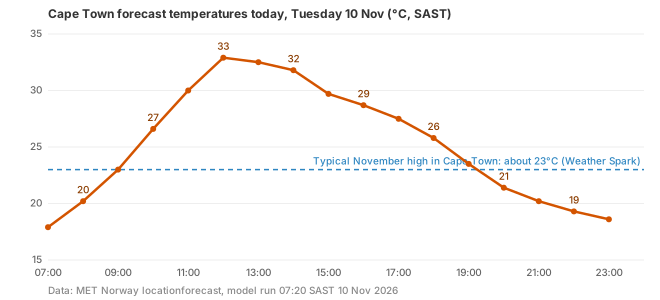
MET Norway's forecast for Cape Town today (07:20 SAST run), against the typical November high of about 23°C. Forecast, not a measurement - the actual peak will be known this evening.
Is this unusual for November?
Yes. According to climate averages compiled by Weather Spark, Cape Town's daily high in November typically runs from about 21°C early in the month to 23°C by the end, and rarely exceeds 27°C. Even on the hottest day of an average year - late January - the typical high is only about 24 to 25°C. A day at 28 to 33°C in November is well outside the norm.
SAWS classifies a heat wave as at least three consecutive days with maximum temperatures 5°C or more above the average of the hottest month. Neither Cape Town nor the interior can be called a heat wave on that definition yet - a single day's advisory and one or two measured hot days do not establish three consecutive qualifying days. SAWS's own products for the region this week are the heat advisory and fire-danger language, not a declared heat wave.
What meteorologists are saying
- Heat advisory: SAWS expects very hot to extremely hot and uncomfortable conditions, with maximum temperatures of 36 to 40°C, over the Namakwa District Municipality in the Northern Cape and the interior of the Western Cape today. Its alert feed also carries a formal heat-health advisory, valid from yesterday morning through 20:59 tonight, covering 17 municipalities including Paarl, Worcester, Ceres, Vredendal and Oudtshoorn in the Western Cape interior and Calvinia, Garies and Pofadder in the Northern Cape. SAWS's advisory text warns of hyperthermia and heat stroke, urges people to limit strenuous outdoor activity - and even flags the heat risk for people queuing to vote in the local elections (SAWS alert feed, 10 November 2026).
- Fire danger: SAWS warns of extremely high fire danger conditions over most of the Northern Cape, southern North West, the central and western Free State, and in places over the north-western Western Cape (SAWS advisory, 10 November 2026).
- Level 10 veld fire warning: SAWS's own alert feed carries a "Warning Level 10 - Veld Fire Conditions", its highest warning category, valid today from 08:00 to 19:59 across 39 municipalities in the Northern Cape, Free State and North West - including Kimberley, Upington, Postmasburg, De Aar, Victoria West and Welkom - and, since this morning, Paarl (Drakenstein), Clanwilliam (Cederberg), Laingsburg and Prince Albert in the Western Cape. SAWS's description of the warning: "Conditions are such that the FDI index is above 75... fires may develop and spread rapidly."
- UV: the UVB sunburn index is forecast to be very high over the Western Cape and extreme over parts of the country, including KwaZulu-Natal (SAWS regional forecasts, 10 November 2026).
- No impact-based severe weather warnings have been issued for the heat itself - SAWS's only warning in force today is the Level 10 veld fire warning above; the heat is covered by an advisory, not a warning (SAWS alert feed, 10 November 2026).
Worth knowing: official severe weather warnings in South Africa come only from SAWS. Outlets like us report and explain them; we do not issue our own.
Why is it happening?
What SAWS has said about this spell. In its 9 November advisory SAWS described the synoptic setup as a surface trough over the central and western interior of South Africa, with a high-pressure system over the eastern parts. Troughs over the western interior are a classic hot-weather pattern for the Cape, but SAWS has not published a detailed attribution for this particular spell - so treat any more specific mechanism with caution.
The general machinery of a heat spell like this. SAWS's standing explanation of how such spells form in the western parts of the country (published in an earlier heat advisory, not specific to this week) is a strong, slow-moving high-pressure system in the upper atmosphere: as the air inside it sinks, it warms on the way down, so surface temperatures climb. When that combines with offshore or berg-wind flow - air moving from the hot interior towards the coast - coastal towns that would normally be cooled by the sea breeze lose that relief, and the heat reaches all the way to the beach.
The seasonal backdrop matters too. South Africa is moving into a summer under a very strong El Niño, and SAWS's Seasonal Climate Watch (31 October 2026) expects above-normal day- and night-time temperatures over most of the country from November to March. One hot spell is not proof of El Niño at work - hot November weeks happened long before this event - but the odds this season are tilted towards more of them. Our full El Niño analysis covers that picture.
What comes next
Relief is close for the city. Both MET Norway and Open-Meteo show Cape Town dropping back to a maximum of about 23 to 25°C from Wednesday, much closer to the November norm. The interior is expected to stay hotter for longer - SAWS's advisories still cover today, so the fire warnings remain the thing to watch. SAWS updates its forecasts and warnings through the day at weathersa.co.za.
SAWS's heat advice, in short
- Drink plenty of water, and limit strenuous outdoor activity between 12:00 and 15:00.
- Stay in shade or well-ventilated spaces where possible; wear loose, light-coloured clothing.
- Check on elderly people and babies, and never leave children or animals in a parked car, even briefly.
- Take the fire danger seriously: no open flames or braais in risky areas, and report smoke to emergency services immediately.
SA Weather Reports publishes its own analysis and advice based on the sources listed below. This is not an official weather warning service - official severe weather warnings are issued only by the South African Weather Service at weathersa.co.za. Forecast temperatures in this article are forecasts, not measurements, and each is marked with its provider and date.
Sources:
· IOL: Tuesday weather - extreme heat and fire danger (10 November 2026) - SAWS advisory and regional forecasts
· The South African: weather today, 10 November 2026 - SAWS town forecasts and Level 10 veld fire warning detail
· The South African: weather today, 9 November 2026 - Monday's SAWS town forecasts
· Cape Argus: Western Cape braces for 40°C heat (9 November 2026) - SAWS advisory and heat precautions
· News24: heatwave grips Western Cape, Northern Cape (8 November 2026) - SAWS forecast for Monday
· SAnews: Hot conditions for parts of SA (9 November 2026) - SAWS's advisory and its synoptic description of this spell
· SAWS alert feed (WarningAlerts) - the Level 10 veld fire warning in force today, checked 10 November 2026
· Ogimet SYNOP reports, Cape Town International (68816) - measured temperatures, 8-10 November 2026
· Ogimet SYNOP reports, Upington (68424) - measured temperatures, 9-10 November 2026
· SAnews: SAWS issues advisory on heatwave - SAWS's general heat-wave definition, mechanism explanation and heat-health advice (not specific to this week)
· Weather Spark: November climate averages for Cape Town
· MET Norway locationforecast for Cape Town (model run 07:20 SAST, 10 November 2026; CC BY 4.0)
· SAWS Seasonal Climate Watch, Nov 2026-Mar 2027 (31 October 2026)